Worldwide Sites

You have been detected as being from . Where applicable, you can see country-specific product information, offers, and pricing.

Change country/language X

Keyboard ALT + g to toggle grid overlay

Chongqing Architectural Design Institute of China (CQADI)

Keep it rolling: How BIM helped speed up a complex interchange project in China

Civil Engineering

Image Courtesy of Chongqing Architectural Design Institute of China

BIM helps deliver multi-layered solution to highway reconstruction project in China

A major reconstruction project in Chongqing focuses on the three longitudinal expressways that traverse the Chinese city. The goal is to ease congestion in the city's districts, and to improve connectivity between Chongqing and Shanghai, as well as other points in China. The Wutaishan interchange project is part of this reconstruction. Spanning 2.94 kilometers at a cost of $202.9 million, the project's challenging parameters included a tight design period and complex engineering problems. The Chongqing Architectural Design Institute of China met these challenges by using BIM and Autodesk technology. Here is how they created and implemented their comprehensive infrastructure design.

Finding the right solution for multi-layered challenges

Revamping existing highways comes with a huge set of complications. In this case, the Wutaishan interchange project involved many overlapping components:

  1. The widening of elevated and underpass main and auxiliary roads.
  2. The creation of a viaduct.
  3. The demolishing of an existing bridge.
  4. The excavation of the underground passage.
  5. Auxiliary roads to ensure smooth traffic flow on and off the Taohuaxi bridge.

As if that wasn't enough, the project planners also faced a series of engineering constraints:

Since the highway traverses through high-density urban areas, the team had to carefully manage land-use considerations.

The highway project involved working with complex mountain topography.

A three-tiered highway featuring bridges, underground passages and a variety of overlapping structures made for challenging engineering interdependencies.

The project had to conform to exacting environmental standards for light and noise pollution. It had to minimize impact on existing traffic.

Widening Bridge of Huaxi River Node

“We also needed multi-regional data viewing and iterative updates from all parties involved in the project," says Hao Fu, Civil Engineer, Chongqing Architectural Design Institute of China, “[so we had to solve] the difficult challenge of coordination between different specialties."

The Chongqing Architectural Design Institute of China created a powerful BIM solution to meet these challenges.

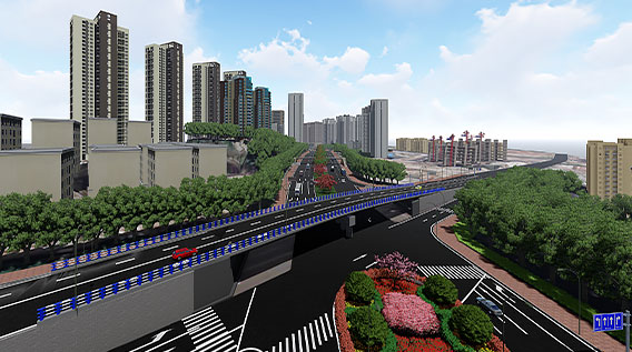
Populating a 3D model from scratch

Transferring the infrastructure project from the real to the digital world involved multiple steps.

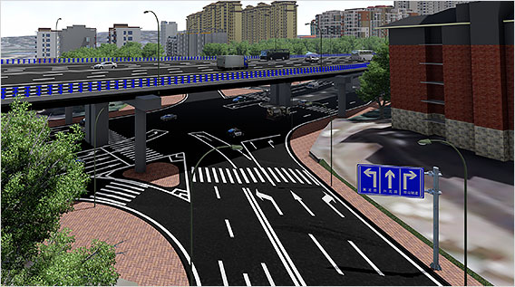
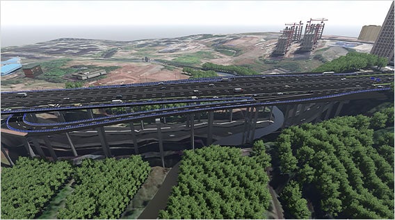
First, the Design Institute had to populate an accurate 3D model. To achieve this, the team uploaded comprehensive tilt drone photographs to Autodesk ReCap. The live 3D model of the reconstruction project worked for reconnaissance and comparison of various model alternatives. Civil 3D also helped with site, route alignment and road subgrade design. Once they exported the data derived from the Civil 3D models into Revit, BIM professionals could factor in structural design considerations for bridges and underground passages. They created the bridge's superstructure by using space coordinate data of proposed design routes generated by Civil 3D. The narrow space constraints for the infrastructure demanded a high level of accuracy at every stage of the process.

There are many special structures, and pipelines intersect with each other heavily, so engineers needed absolute accuracy to optimize design and analysis,

Hao Fu, Civil Engineer, Chongqing Architectural Design Institute of China

Hengsheng Avenue Interchange Node

The project planners achieved said accuracy with the help of the Autodesk suite. It worked in concert to help the Design Institute solve complicated engineering problems.

The project planners achieved said accuracy with the help of the Autodesk suite. It worked in concert to help the Design Institute solve complicated engineering problems.

Meeting strict environmental regulations with BIM

Hengsheng Avenue Interchange Node

The infrastructure project had to conform to stringent environmental impact standards, and Chongqing's urban density compounded the problem.

By importing all models into Infraworks, the team conducted simulations of light and noise pollution, and traffic flow changes. Such what-if modeling ensured that new infrastructure parameters would meet strict environmental regulations.

Throughout the project, granular BIM features helped the designers to dig deep down for efficiencies. For example, Civil 3D's earth-rock volume and filling estimates helped gauge transport costs for material and minimize disruption of the surrounding environment.

Meeting strict environmental regulations with BIM

The infrastructure project had to conform to stringent environmental impact standards, and Chongqing's urban density compounded the problem.

By importing all models into Infraworks, the team conducted simulations of light and noise pollution, and traffic flow changes. Such what-if modeling ensured that new infrastructure parameters would meet strict environmental regulations.

Throughout the project, granular BIM features helped the designers to dig deep down for efficiencies. For example, Civil 3D's earth-rock volume and filling estimates helped gauge transport costs for material and minimize disruption of the surrounding environment.

The structural engineering quantity list produced by Revit has replaced the traditional handwritten statistical list, which improves the accuracy of materials.

Hao Fu, Civil Engineer, Chongqing Architectural Design Institute of China

Collaboration through the cloud

The highway reconstruction project involved multiple engineering specialties, including bridge, tunnel, traffic, drainage, landscape, and lighting. They collected all their data and input from multiple stakeholders via the BIM 360 Cloud. Using one true model also facilitated project review from various government departments.

The data hosted in BIM360 can be provided to project participants for review, which greatly improves the communication efficiency and progress of the project, reduces design changes and speeds up project approval.

Hao Fu, Civil Engineer, Chongqing Architectural Design Institute of China

Hongshi Avenue Interchange Node

In the final stages, the project planners extended BIM applications of BIM through Navisworks. Collision checking ensured bridges and viaducts were at the right heights. Using virtual reality, the team immersed themselves in various scenarios to review related aspects of the final project. BIM also helped evaluate landscaping alternatives and how daily lighting conditions might affect driving safety.

BIM execution in challenging environment

The integration of 3D BIM with traditional design processes helped Chongqing Architectural Design Institute of China realize project goals on time and within budget. It allowed for better definition of the spatial relationships between the proposed project and the surrounding terrain.

Project planners could pinpoint and rectify potential design problems in advance, to save costs. For example, the project design initially overlooked an interpenetration of structures at Pier1 Hengsheng Interchange. Through BIM visual modeling and analysis, they consolidated the pier and ground passage. The net result met new design specifications.

With its seamless design, planning and analysis, the Wutaishan interchange project is well on its way to improve traffic conditions in Chongqing. The infrastructure project was a finalist at the AEC 2019 Excellence Awards.

Key takeaways

  • BIM helps manage infrastructure projects in mountainous regions that involve geology and gradient considerations.
  • BIM allows designers to envision what-if scenarios of various options to minimize traffic disruptions for citizens.
  • Cloud collaboration helps speed up timelines and solve complex design solutions.

Related products

A version of this article ran previously on website. Photos courtesy of [credit].

BIM FOR CIVIL ENGINEERING

Use intelligent, connected BIM (Building Information Modeling) workflows to help improve the outcomes of your infrastructure projects.